Robert C. Byrd Lock and Dam
| Robert C. Byrd Lock and Dam | |
|---|---|
 | |
| Official name | Robert C. Byrd Lock and Dam |
| Location | Ohio/West Virginia border |
| Coordinates | 38°40′54″N 82°11′24″W / 38.6816°N 82.1900°WCoordinates: 38°40′54″N 82°11′24″W / 38.6816°N 82.1900°W |
| Construction began | August 25, 1937 |
| Opening date | October 1937 |
| Construction cost |
Lock Replacement $244,550,000 |
| Operator(s) |
|
| Dam and spillways | |
| Type of dam | 8 Roller gates |
| Impounds | Ohio River |
| Length | 1,132 feet |
| Reservoir | |
| Normal elevation | 538 feet above sealevel |
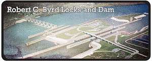
Robert C. Byrd Lock and Dam is the 10th Lock and dam on the Ohio River, located 280 miles down stream of Pittsburgh. There are 4 locks, one for commercial barge traffic that's 1,200 feet long by 110 feet wide, and the auxiliary lock is 600 feet long by 110 feet wide, and 2 smaller parallel locks.[1]
See also
References
External links
- U.S. Army Corps of Engineers, Pittsburgh District
- U.S. Army Corps of Engineers, Huntington District
- U.S. Army Corps of Engineers, Louisville District
This article is issued from Wikipedia - version of the 10/24/2016. The text is available under the Creative Commons Attribution/Share Alike but additional terms may apply for the media files.