Arrondissement of Roeselare
| Arrondissement of Roeselare Arrondissement Roeselare | |
|---|---|
| Arrondissement | |
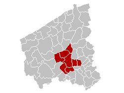 Location of the arrondissement in West Flanders | |
| Coordinates: 50°55′N 03°10′E / 50.917°N 3.167°ECoordinates: 50°55′N 03°10′E / 50.917°N 3.167°E | |
| Country |
|
| Region |
|
| Province |
|
| Municipalities | 8 |
| Area | |
| • Total | 271.54 km2 (104.84 sq mi) |
| Population (1 January 2015) | |
| • Total | 148,778 |
| • Density | 550/km2 (1,400/sq mi) |
| Time zone | CET (UTC+1) |
| • Summer (DST) | CEST (UTC+2) |
The Arrondissement of Roeselare (Dutch: Arrondissement Roeselare; French: Arrondissement de Roulers) is one of the eight administrative arrondissements in the Province of West Flanders, Belgium.
The Administrative Arrondissement of Roeselare consists of the following municipalities:
This article is issued from Wikipedia - version of the 11/27/2015. The text is available under the Creative Commons Attribution/Share Alike but additional terms may apply for the media files.