Rothenbachkopf
| Rothenbachkopf | |
|---|---|
|
The Rothenbachkopf from the north | |
| Highest point | |
| Elevation | 1,315 m (4,314 ft) |
| Coordinates | 48°00′04″N 6°58′50″E / 48.001152°N 6.980667°ECoordinates: 48°00′04″N 6°58′50″E / 48.001152°N 6.980667°E |
| Geography | |
 Rothenbachkopf | |
| State/Province | FR-68 |
| Parent range | Vosges |
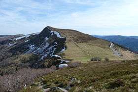
The Rothenbachkopf is a mountain, 1,315 metres high, in the High Vosges. Only a few metres to the west of the summit runs the Route des Crêtes heading south from the Col de la Schlucht. Several Vosges Club hiking trails run over the top. A few kilometres north of the Rothenbachkopfs the border between Alsace and Lorraine turns and heads southwest.
Mapping
Cartes IGN 31 (Série verte): St-Dié – Mulhouse – Bâle, 1:100.000, Edition 8, Institut Géographique Nationale, Paris, 1990
External links
| Wikimedia Commons has media related to Rothenbachkopf. |
This article is issued from Wikipedia - version of the 11/28/2016. The text is available under the Creative Commons Attribution/Share Alike but additional terms may apply for the media files.