Rucmanci
| Rucmanci | |
|---|---|
 Rucmanci Location in Slovenia | |
| Coordinates: 46°29′25.35″N 16°1′12.38″E / 46.4903750°N 16.0201056°ECoordinates: 46°29′25.35″N 16°1′12.38″E / 46.4903750°N 16.0201056°E | |
| Country |
|
| Traditional region | Styria |
| Statistical region | Drava |
| Municipality | Sveti Tomaž |
| Area | |
| • Total | 4.74 km2 (1.83 sq mi) |
| Elevation | 301.4 m (988.8 ft) |
| Population (2002) | |
| • Total | 231 |
| [1] | |
Rucmanci (pronounced [ˈɾuːtsmantsi]) is a settlement in the Slovene Hills (Slovene: Slovenske gorice) in the Municipality of Sveti Tomaž in northeastern Slovenia. The area traditionally belonged to the Styria region and is now included in the Drava Statistical Region.[2]
The village chapel-shrine with a belfry was built in 1905.[3]
References
External links
| Settlements | 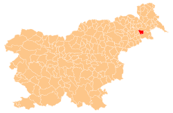 | |
|---|---|---|
| Landmarks |
| |
This article is issued from Wikipedia - version of the 9/1/2016. The text is available under the Creative Commons Attribution/Share Alike but additional terms may apply for the media files.