São Luiz Gonzaga
For other uses, see São Luís.
| São Luiz Gonzaga | |
|---|---|
| Municipality | |
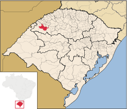 Location in Rio Grande do Sul state | |
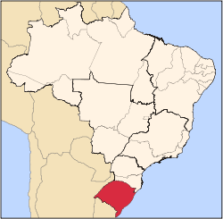
 São Luiz Gonzaga Location in Brazil | |
| Coordinates: 28°24′28″S 54°57′39″W / 28.40778°S 54.96083°WCoordinates: 28°24′28″S 54°57′39″W / 28.40778°S 54.96083°W | |
| Country |
|
| State | Rio Grande do Sul |
| Micro-region | Santo Ângelo |
| Area | |
| • Total | 1,295.68 km2 (500.26 sq mi) |
| Population (2015) | |
| • Total | 35,193 |
| • Density | 27/km2 (70/sq mi) |
| Time zone | BRT (UTC-3) |
| • Summer (DST) | BRST (UTC-2) |
São Luiz Gonzaga (Portuguese for St. Aloysius Gonzaga) is a municipality of the state of Rio Grande do Sul, Brazil. The population is 35,193 (2015 est.) in an area of 1295,68 km².[1] It was founded in the 17th century as a Jesuit mission town. It is located 503 km west of the state capital of Porto Alegre, northeast of Alegrete.
Bounding municipalities
- Roque Gonzales
- Rolador
- Caibaté
- São Miguel das Missões
- Bossoroca
- Santo Antônio das Missões
- São Nicolau, Rio Grande do Sul
- Dezesseis de Novembro
References
External links
- http://www.citybrazil.com.br/rs/saoluizgonzaga/ (Portuguese)
This article is issued from Wikipedia - version of the 5/15/2016. The text is available under the Creative Commons Attribution/Share Alike but additional terms may apply for the media files.