ST postcode area
Postcode district boundaries: Bing / Google
| Stoke-on-Trent postcode area | |
|---|---|
 ST | |
| Postcode area | ST |
| Postcode area name | Stoke-on-Trent |
| Post towns | 6 |
| Postcode districts | 22 |
| Postcode sectors | 90 |
| Postcodes (live) | 17,469 |
| Postcodes (total) | 21,885 |
| Statistics as at February 2012[1] | |
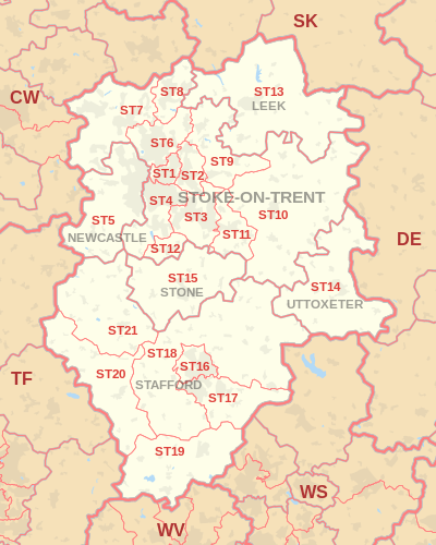
The ST postcode area, also known as the Stoke-on-Trent postcode area,[2] is a group of 21 postcode districts in England, which are subdivisions of six post towns. These postcode districts cover much of north and central Staffordshire, including Stoke-on-Trent, Stafford, Leek, Newcastle-under-Lyme, Stone and Uttoxeter, plus very small parts of Cheshire and Derbyshire.
Coverage
The approximate coverage of the postcode districts:
| Postcode district | Post town | Coverage | Local authority area |
|---|---|---|---|
| ST1 | STOKE-ON-TRENT | Hanley, Cobridge, Sneyd Green, Birches Head, Shelton | Stoke-on-Trent |
| ST2 | STOKE-ON-TRENT | Bentilee, Abbey Hulton, Bucknall | Stoke-on-Trent, Staffordshire Moorlands |
| ST3 | STOKE-ON-TRENT | Longton, Meir, Blurton, Weston Coyney | Stoke-on-Trent, Stafford, Staffordshire Moorlands |
| ST4 | STOKE-ON-TRENT | Stoke, Fenton, Penkhull, Trentham | Stoke-on-Trent, Stafford |
| ST5 | NEWCASTLE | Newcastle-under-Lyme, Keele, Chesterton | Newcastle-under-Lyme, Stafford |
| ST6 | STOKE-ON-TRENT | Tunstall, Burslem, Smallthorne, Brown Edge | Stoke-on-Trent, Staffordshire Moorlands |
| ST7 | STOKE-ON-TRENT | Kidsgrove, Talke, Talke Pits, Alsager, Mow Cop, Audley | Newcastle-under-Lyme, Cheshire East, Stoke-on-Trent, Staffordshire Moorlands |
| ST8 | STOKE-ON-TRENT | Biddulph | Staffordshire Moorlands, Stoke-on-Trent |
| ST9 | STOKE-ON-TRENT | Werrington, Endon | Staffordshire Moorlands, Stoke-on-Trent |
| ST10 | STOKE-ON-TRENT | Cheadle, Church Leigh, Tean, Alton | Staffordshire Moorlands, East Staffordshire |
| ST11 | STOKE-ON-TRENT | Blythe Bridge | Staffordshire Moorlands, Stafford |
| ST12 | STOKE-ON-TRENT | Barlaston | Stafford, Stoke-on-Trent |
| ST13 | LEEK | Leek | Staffordshire Moorlands |
| ST14 | UTTOXETER | Uttoxeter, Bramshall, Stramshall | East Staffordshire, Derbyshire Dales |
| ST15 | STONE | Stone | Stafford, Staffordshire Moorlands |
| ST16 | STAFFORD | Stafford | Stafford |
| ST17 | STAFFORD | Stafford | Stafford, South Staffordshire |
| ST18 | STAFFORD | Stafford | Stafford, South Staffordshire, East Staffordshire |
| ST19 | STAFFORD | Penkridge | South Staffordshire |
| ST20 | STAFFORD | Stafford, Woodseaves, Norbury | Stafford |
| ST21 | STAFFORD | Stafford, Eccleshall, Rodbaston | Stafford |
Map
See also
References
- ↑ "ONS Postcode Directory Version Notes" (ZIP). National Statistics Postcode Products. Office for National Statistics. February 2012. Table 2. Retrieved 21 April 2012. Coordinates from mean of unit postcode points, "Code-Point Open". OS OpenData. Ordnance Survey. February 2012. Retrieved 21 April 2012.
- ↑ Royal Mail, Address Management Guide, (2004)
External links
This article is issued from Wikipedia - version of the 9/16/2016. The text is available under the Creative Commons Attribution/Share Alike but additional terms may apply for the media files.