Saint-Cyr-de-Salerne
| Saint-Cyr-de-Salerne | |
|---|---|
|
Saint-Cyr-et-Sainte-Julitte | |
 Saint-Cyr-de-Salerne | |
|
Location within Normandy region  Saint-Cyr-de-Salerne | |
| Coordinates: 49°11′02″N 0°39′31″E / 49.1839°N 0.6586°ECoordinates: 49°11′02″N 0°39′31″E / 49.1839°N 0.6586°E | |
| Country | France |
| Region | Normandy |
| Department | Eure |
| Arrondissement | Bernay |
| Canton | Brionne |
| Government | |
| • Mayor (2008–2014) | Yvon Heutte |
| Area1 | 6.38 km2 (2.46 sq mi) |
| Population (2008)2 | 216 |
| • Density | 34/km2 (88/sq mi) |
| Time zone | CET (UTC+1) |
| • Summer (DST) | CEST (UTC+2) |
| INSEE/Postal code | 27527 / 27800 |
| Elevation |
83–163 m (272–535 ft) (avg. 148 m or 486 ft) |
|
1 French Land Register data, which excludes lakes, ponds, glaciers > 1 km² (0.386 sq mi or 247 acres) and river estuaries. 2 Population without double counting: residents of multiple communes (e.g., students and military personnel) only counted once. | |
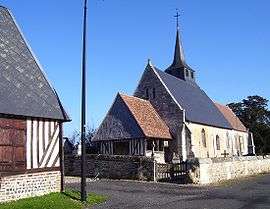
Saint-Cyr-de-Salerne is a commune in the Eure department in Haute-Normandie in northern France.
Population
| Historical population | ||
|---|---|---|
| Year | Pop. | ±% |
| 1962 | 188 | — |
| 1968 | 197 | +4.8% |
| 1975 | 185 | −6.1% |
| 1982 | 207 | +11.9% |
| 1990 | 209 | +1.0% |
| 1999 | 211 | +1.0% |
| 2008 | 216 | +2.4% |
See also
References
| Wikimedia Commons has media related to Saint-Cyr-de-Salerne. |
This article is issued from Wikipedia - version of the 2/11/2016. The text is available under the Creative Commons Attribution/Share Alike but additional terms may apply for the media files.