Saint-Malo-de-Beignon
| Saint-Malo-de-Beignon Sant-Maloù-Benion | ||
|---|---|---|
|
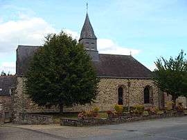
The Church of Saint-Malo, in Saint-Malo-de-Beignon | ||
| ||
 Saint-Malo-de-Beignon | ||
|
Location within Brittany region  Saint-Malo-de-Beignon | ||
| Coordinates: 47°57′34″N 2°08′54″W / 47.9594°N 2.1483°WCoordinates: 47°57′34″N 2°08′54″W / 47.9594°N 2.1483°W | ||
| Country | France | |
| Region | Brittany | |
| Department | Morbihan | |
| Arrondissement | Vannes | |
| Canton | Guer | |
| Intercommunality | Pays de Guer | |
| Government | ||
| • Mayor (2008—2014) | Henri Mauvoisin | |
| Area1 | 3.49 km2 (1.35 sq mi) | |
| Population (1999)2 | 385 | |
| • Density | 110/km2 (290/sq mi) | |
| Time zone | CET (UTC+1) | |
| • Summer (DST) | CEST (UTC+2) | |
| INSEE/Postal code | 56226 / 56380 | |
| Elevation | 50–153 m (164–502 ft) | |
|
1 French Land Register data, which excludes lakes, ponds, glaciers > 1 km² (0.386 sq mi or 247 acres) and river estuaries. 2 Population without double counting: residents of multiple communes (e.g., students and military personnel) only counted once. | ||
.svg.png)
Saint-Malo-de-Beignon (Breton: Sant-Maloù-Benion) is a commune in the Morbihan department of Brittany in north-western France.
Demographics
Inhabitants of Saint-Malo-de-Beignon are called in French Maloins.
See also
References
External links
| Wikimedia Commons has media related to Saint-Malo-de-Beignon. |
- French Ministry of Culture list for Saint-Malo-de-Beignon (French)
- Map of Saint-Malo-de-Beignon on Michelin (English)
This article is issued from Wikipedia - version of the 2/13/2015. The text is available under the Creative Commons Attribution/Share Alike but additional terms may apply for the media files.