Saint-Pierre-de-Broughton, Quebec
| Saint-Pierre-de-Broughton | |
|---|---|
| Municipality | |
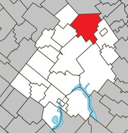 Location within Les Appalaches RCM. | |
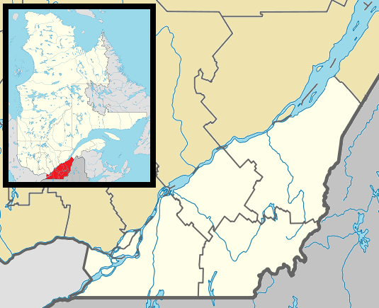 Saint-Pierre -de-Broughton Location in southern Quebec. | |
| Coordinates: 46°15′N 71°12′W / 46.250°N 71.200°WCoordinates: 46°15′N 71°12′W / 46.250°N 71.200°W[1] | |
| Country |
|
| Province |
|
| Region | Chaudière-Appalaches |
| RCM | Les Appalaches |
| Constituted | October 12, 1974 |
| Government[2] | |
| • Mayor | Nicole Bourque |
| • Federal riding | Mégantic—L'Érable |
| • Prov. riding | Lotbinière-Frontenac |
| Area[2][3] | |
| • Total | 148.50 km2 (57.34 sq mi) |
| • Land | 150.13 km2 (57.97 sq mi) |
|
There is an apparent contradiction between two authoritative sources | |
| Population (2011)[3] | |
| • Total | 882 |
| • Density | 5.9/km2 (15/sq mi) |
| • Pop 2006-2011 |
|
| • Dwellings | 436 |
| Time zone | EST (UTC−5) |
| • Summer (DST) | EDT (UTC−4) |
| Postal code(s) | G0N 1T0 |
| Area code(s) | 418 and 581 |
| Highways |
|
| Website |
www -de-broughton |
Saint-Pierre-de-Broughton is a municipality located in the Municipalité régionale de comté des Appalaches in Quebec, Canada. It is part of the Chaudière-Appalaches region and the population is 883 as of 2009.
References
- Commission de toponymie du Québec
- Ministère des Affaires municipales, des Régions et de l'Occupation du territoire
 |
Saint-Jacques-de-Leeds | Saint-Sylvestre | Saint-Séverin | |
| |
Sacré-Coeur-de-Jésus | |||
| ||||
| | ||||
| Kinnear's Mills | Thetford Mines |
| Cities & Towns | |
|---|---|
| Municipalities | |
| Parishes | |
| |
This article is issued from Wikipedia - version of the 10/27/2016. The text is available under the Creative Commons Attribution/Share Alike but additional terms may apply for the media files.