Sainte-Anastasie, Gard
| Sainte-Anastasie | ||
|---|---|---|
|
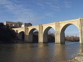
Saint-Nicolas-de-Campagnac bridge over the Gardon | ||
| ||
 Sainte-Anastasie | ||
|
Location within Occitanie region  Sainte-Anastasie | ||
| Coordinates: 43°56′10″N 4°19′21″E / 43.9361°N 4.3225°ECoordinates: 43°56′10″N 4°19′21″E / 43.9361°N 4.3225°E | ||
| Country | France | |
| Region | Occitanie | |
| Department | Gard | |
| Arrondissement | Nîmes | |
| Canton | Saint-Chaptes | |
| Government | ||
| • Mayor (2008–2014) | Claude Vian | |
| Area1 | 43.64 km2 (16.85 sq mi) | |
| Population (2008)2 | 1,617 | |
| • Density | 37/km2 (96/sq mi) | |
| Time zone | CET (UTC+1) | |
| • Summer (DST) | CEST (UTC+2) | |
| INSEE/Postal code | 30228 / 30190 | |
| Elevation |
33–207 m (108–679 ft) (avg. 70 m or 230 ft) | |
|
1 French Land Register data, which excludes lakes, ponds, glaciers > 1 km² (0.386 sq mi or 247 acres) and river estuaries. 2 Population without double counting: residents of multiple communes (e.g., students and military personnel) only counted once. | ||
.svg.png)
Sainte-Anastasie is a commune in the Gard department in southern France.
Population
| Historical population | ||
|---|---|---|
| Year | Pop. | ±% |
| 1962 | 706 | — |
| 1968 | 708 | +0.3% |
| 1975 | 732 | +3.4% |
| 1982 | 870 | +18.9% |
| 1990 | 1,028 | +18.2% |
| 1999 | 1,270 | +23.5% |
| 2008 | 1,617 | +27.3% |
Sights
See also
References
| Wikimedia Commons has media related to Sainte-Anastasie (Gard). |
This article is issued from Wikipedia - version of the 8/16/2016. The text is available under the Creative Commons Attribution/Share Alike but additional terms may apply for the media files.