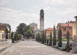
San Martino in Strada
| San Martino in Strada | ||
|---|---|---|
| Comune | ||
| Comune di San Martino in Strada | ||
 | ||
| ||
 | ||
 San Martino in Strada Location of San Martino in Strada in Italy | ||
| Coordinates: 45°18′N 9°35′E / 45.300°N 9.583°ECoordinates: 45°18′N 9°35′E / 45.300°N 9.583°E | ||
| Country | Italy | |
| Region | Lombardy | |
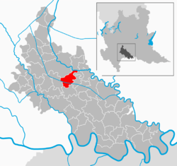
| Province / Metropolitan city | Province of Lodi (LO) | |
| Frazioni | Sesto, Ca´ del Conte | |
| Area | ||
| • Total | 13.1 km2 (5.1 sq mi) | |
| Elevation | 73 m (240 ft) | |
| Population (Dec. 2004) | ||
| • Total | 3,595 | |
| • Density | 270/km2 (710/sq mi) | |
| Demonym(s) | Sammartinesi | |
| Time zone | CET (UTC+1) | |
| • Summer (DST) | CEST (UTC+2) | |
| Postal code | 26817 | |
| Dialing code | 0371 | |
| Website | Official website | |

San Martino in Strada is a comune (municipality) in the Province of Lodi in the Italian region Lombardy, located about 40 kilometres (25 mi) southeast of Milan and about 7 kilometres (4 mi) southeast of Lodi. As of 31 December 2004, it had a population of 3,595 and an area of 13.1 square kilometres (5.1 sq mi).[1]
The municipality of San Martino in Strada contains the frazioni (subdivisions, mainly villages and hamlets) Sesto and Ca´ del Conte.
San Martino in Strada borders the following municipalities: Lodi, Corte Palasio, Cavenago d'Adda, Cornegliano Laudense, Massalengo, Ossago Lodigiano.
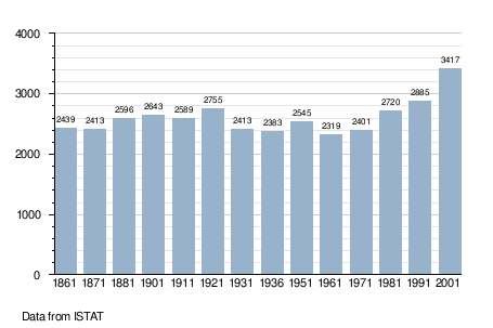
Demographic evolution
References
External links
This article is issued from Wikipedia - version of the 1/31/2015. The text is available under the Creative Commons Attribution/Share Alike but additional terms may apply for the media files.