Sangobeg
| Sangobeg | |
| Scottish Gaelic: Saingea Beag | |
 |
|
 Sangobeg |
|
| Population | 6 |
|---|---|
| OS grid reference | NC427659 |
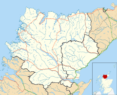
| Council area | Highland |
| Lieutenancy area | Sutherland |
| Country | Scotland |
| Sovereign state | United Kingdom |
| Post town | Durness |
| Postcode district | IV27 4 |
| Dialling code | 01971 |
| Police | Scottish |
| Fire | Scottish |
| Ambulance | Scottish |
| EU Parliament | Scotland |
Coordinates: 58°33′13″N 4°42′13″W / 58.55348°N 4.70361°W
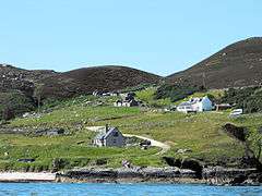
Sangobeg (Scottish Gaelic: Saingea Beag) is a remote coastal crofting township which overlooks Sangobeg Sands in Sutherland, Scottish Highlands in the Scottish council area of Highland. A legacy of the clearances, this small township sits near the township of Leirinmore on the edge of Durness around 1 mile (1.6 km) northwest along the A838 road.
| Wikimedia Commons has media related to Sangobeg. |
This article is issued from Wikipedia - version of the 2/16/2016. The text is available under the Creative Commons Attribution/Share Alike but additional terms may apply for the media files.