Schulzengrundbach
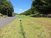 | |
| The Schulzengrundbach in Westerngrund-Oberwestern | |
| Location | Landkreis Aschaffenburg (Bavaria) |
|---|---|
| Length | 1.0 km [1] |
| Source | östlich von Westerngrund-Oberwestern 50°07′08″N 9°15′16″E / 50.118803°N 9.254500°ECoordinates: 50°07′08″N 9°15′16″E / 50.118803°N 9.254500°E |
| Source height | 280 m above sea level (NN) |
| Mouth | in Westerngrund-Oberwestern into the Westerbach 50°06′57″N 9°14′29″E / 50.115826°N 9.241409°E |
| Mouth height | 240 m above sea level (NN) |
| Descent | 40 m |
| Basin | Rhine |
| Progression | Westerbach → Kahl → Main (river) → Rhein → Nordsee |
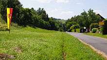 | |
| Geographical centre point of the European Union marked by the flag pole on the bank of the Schulzengrundbach in Westerngrund-Oberwestern | |
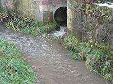 | |
| The Schulzengrundbach flows through a tube into the Westerbach | |
The Schulzengrundbach[2] is a small river left of the Westerbach in Landkreis Aschaffenburg in the Bavarian Spessart in Germany.
Location
Its source is east of Westerngrund-Oberwestern. It flows in southwesterly direction through the Schulzengrund valley and discharges in Oberwestern into the Westerbach.
Since 1 July 2013 it became famous, because the Geographic centre of the European Union is located in a wet meadow left of the Schulzengrundbach, when Croatia joined the European Union.[3][4]
References
- ↑ Google Earth
- ↑ Main-Echo Aschaffenburg, 21 July 2012: Grenzbach, Bindeglied, wildes Wasser: Durch Westerngrund (10): Der Westerbach – Namensgeber der Gemeinde – Einst zehn Mühlen angetrieben – verheerende Flut im August 1981. (German)
- ↑ Westerngrund ist Mittelpunkt der Europäischen Union. (German)
- ↑ Der Mittelpunkt ist eine feuchte Wiese in Oberwestern. (German)
| Wikimedia Commons has media related to Schulzengrundbach. |
This article is issued from Wikipedia - version of the 5/19/2016. The text is available under the Creative Commons Attribution/Share Alike but additional terms may apply for the media files.