Selja, Selje
 View of Selja island from Selje village | |
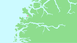 Location in Sogn og Fjordane county | |
| Geography | |
|---|---|
| Location | Sogn og Fjordane, Norway |
| Coordinates | 62°02′55″N 5°17′43″E / 62.0487°N 5.2952°E |
| Area | 1.6 km2 (0.62 sq mi) |
| Length | 1.4 km (0.87 mi) |
| Width | 1.5 km (0.93 mi) |
| Highest elevation | 201 m (659 ft) |
| Highest point | Varden |
| Administration | |
| County | Sogn og Fjordane |
| Municipality | Selje Municipality |
Selja is a small island in Selje Municipality in Sogn og Fjordane county, Norway. It has been formerly known as Sellø or Selø. The island is located in the Sildagapet bay, just 1 kilometre (0.62 mi) west of the harbor in the village of Selje. The sparsely populated island has about 5 permanent residents who commute by boat to the mainland since the island is not accessible by road.
The island is mainly known for its connection to Saint Sunniva, who, according to legend, landed and died there in the late 10th century. Today, the ruins of a monastery named "Sankta Sunniva kloster" (Selje Abbey) is the only notable feature on the island. The cave of Saint Sunniva and the ruins of an early (and very small) cathedral are also located on the island. The cathedral is the predecessor of the Ancient Diocese of Bergen.[1]
The painter Bernt Tunold grew up on the island, where his parents had established a farm on the church grounds.
Media gallery
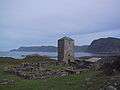 View of the Church ruins on the island
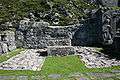 Altar in the Albanus Church in the Abbey
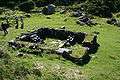 The forge at the abbey
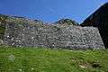 A wall in front of the Sunniva Church
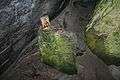 Altar in the Mikaels Church in the Abbey
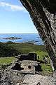 Cliff at the entrance to the Mikaels Church
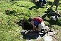 Well at Sunniva Church
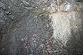 Runestone in the abbey tower
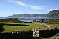 Church yard
References
- ↑ Store norske leksikon. "Selja" (in Norwegian). Retrieved 2010-07-11.