Semuc Champey
| Semuc Champey Natural Monument | |
| II | |
 pools in the Cahabòn River | |
| Country | Guatemala |
|---|---|
| Region | Alta Verapaz |
| River | Cahabón River |
| Location | Lanquín |
| - elevation | 380 m (1,247 ft) |
| - coordinates | 15°32′0″N 89°57′41″W / 15.53333°N 89.96139°WCoordinates: 15°32′0″N 89°57′41″W / 15.53333°N 89.96139°W |
| Area | 17.14 km2 (7 sq mi) |
| Geology | Karst |
| Founded | Decreto No. 025 2005 |
| Date | 2005 |
| Management | CONAP, Municipality of Languín |
| Website: www.semucchampey.com | |
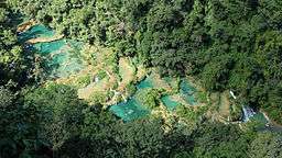
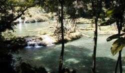
Semuc Champey is a natural monument in the department of Alta Verapaz, Guatemala, near the Q'eqchi' Maya town of Lanquín. It consists of a natural 300 m limestone bridge, under which passes the Cahabón River. Atop the bridge is a series of stepped, turquoise pools, a popular swimming attraction. Although it can be difficult to get to, Semuc is becoming more and more popular with travelers.[1]
Gallery
.JPG)
.JPG)
.JPG)
References
- ↑ Joice Maynard (2012-09-14). "In Guatemala, a Torturous Drive to a Remote Eden". The New York Times. Retrieved 2012-09-16.
External links
| Wikimedia Commons has media related to Semuc Champey. |
This article is issued from Wikipedia - version of the 2/23/2015. The text is available under the Creative Commons Attribution/Share Alike but additional terms may apply for the media files.