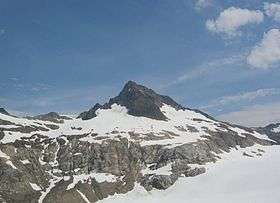
Sentinel Peak (Washington)
| Sentinel Peak | |
|---|---|
 | |
| Highest point | |
| Elevation | 8,266 ft (2,519 m) NAVD 88[1] |
| Coordinates | 48°21′22″N 121°02′27″W / 48.3562322°N 121.040841694°WCoordinates: 48°21′22″N 121°02′27″W / 48.3562322°N 121.040841694°W [2] |
| Geography | |
| Location | Skagit County, Washington, U.S. |
| Parent range | Cascade Range, North Cascades |
| Topo map | USGS Dome Peak |
Sentinel Peak is located in the Glacier Peak Wilderness of Washington's North Cascades.[1] The summit is part of the Ptarmigan Traverse.[3]
See also
References
- 1 2 "Sentinel Peak, Washington". Peakbagger.com. Retrieved 7 August 2013.
- ↑ "Sentinel Peak". NGS data sheet. U.S. National Geodetic Survey. Retrieved 28 March 2014.
- ↑ "Sentinel Peak". SummitPost.org. Retrieved 28 March 2014.
External links
 Media related to Sentinel Peak (Washington) at Wikimedia Commons
 - "Sentinel Peak". Geographic Names Information System. United States Geological Survey.
This article is issued from Wikipedia - version of the 12/7/2015. The text is available under the Creative Commons Attribution/Share Alike but additional terms may apply for the media files.