Sherwood, Oklahoma
| Sherwood, Oklahoma | |
|---|---|
| Unincorporated community | |
 Sherwood, Oklahoma | |
| Coordinates: 34°19′52″N 94°46′42″W / 34.33111°N 94.77833°WCoordinates: 34°19′52″N 94°46′42″W / 34.33111°N 94.77833°W | |
| Country | United States |
| State | Oklahoma |
| County | McCurtain |
| Elevation | 1,040 ft (320 m) |
| Time zone | Central (CST) (UTC-6) |
| • Summer (DST) | CDT (UTC-5) |
| Area code(s) | Area code 580 |
| GNIS feature ID | 1100830[1] |
Sherwood is an unincorporated community in McCurtain County, Oklahoma, United States.[1] The community is 4 miles (6.4 km) southeast of Bethel. A post office opened in Sherwood on March 20, 1912. The community was named for early settler Sherwood Davis.[2]
References
- 1 2 "Sherwood". Geographic Names Information System. United States Geological Survey.
- ↑ Shirk, George H. (1974). Oklahoma Place Names (2 ed.). Norman, Oklahoma: University of Oklahoma Press. p. 219. ISBN 0806111402.
Municipalities and communities of McCurtain County, Oklahoma, United States | ||
|---|---|---|
| Cities | 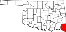 | |
| Towns | ||
| CDP | ||
| Other unincorporated communities |
| |
| Ghost towns | ||
This article is issued from Wikipedia - version of the 10/23/2016. The text is available under the Creative Commons Attribution/Share Alike but additional terms may apply for the media files.