Sialan
| Sialan | |
|---|---|
 | |
| Highest point | |
| Elevation | 4,185 m (13,730 ft) |
| Coordinates | 36°30′42.6″N 50°41′55.2″E / 36.511833°N 50.698667°ECoordinates: 36°30′42.6″N 50°41′55.2″E / 36.511833°N 50.698667°E |
| Geography | |
 Sialan Border of Mazandaran and Qazvin, Iran | |
| Parent range | Alborz |
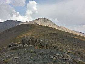
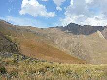
Sialan is a mountain peak in Alborz range in Iran. At an elevation of 4,185 metres (13,730 ft) it is famous mountain in the range. Its south face rises from the Alamut valley.
| Map of central Alborz | Peaks: | 1 `Alam Kūh |
|---|---|---|
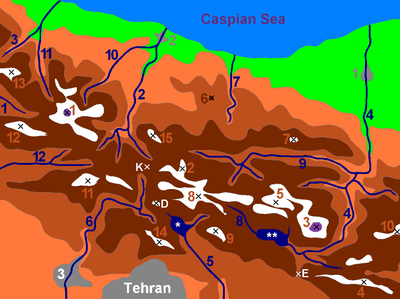 -25 to 500 m 500 to 1500 m 1500 to 2500 m 2500 to 3500 m 3500 to 4500 m 4500 to 5671 m |
2 Āzād Kūh | 3 Damāvand |
| 4 Do Berar | 5 Do Khaharan | |
| 6 Ghal`eh Gardan | 7 Gorg | |
| 8 Kholeno | 9 Mehr Chal | |
| 10 Mīšīneh Marg | 11 Naz | |
| 12 Shah Alborz | 13 Sīālān | |
| 14 Tochal | 15 Varavašt | |
| Rivers: | 0 | |
| 1 Alamūt | 2 Chālūs | |
| 3 Do Hezār | 4 Harāz | |
| 5 Jājrūd | 6 Karaj | |
| 7 Kojūr | 8 Lār | |
| 9 Nūr | 10 Sardāb | |
| 11 Seh Hazār | 12 Shāh Rūd | |
| Cities: | 1 Āmol | |
| 2 Chālūs | 3 Karaj | |
| Other: | D Dīzīn | |
| E Emāmzādeh Hāšem | K Kandovān Tunnel | |
| * Latīān Dam | ** Lār Dam |
Climbing
The level of difficulty is "walk-up" and the nearest center is Haniz village. There is a hut at 3270 m for climbers from the Southern valley.
Mount Sialan: +36° 30' 42.6", +50° 41' 55.2", 4185 m and Sialan shelter: +36° 30' 21.10", +50° 40' 9.10", 3271 m
References
This article is issued from Wikipedia - version of the 12/5/2016. The text is available under the Creative Commons Attribution/Share Alike but additional terms may apply for the media files.