Simmie, Saskatchewan
| Simmie, Saskatchewan | |
|---|---|
| Hamlet | |
|
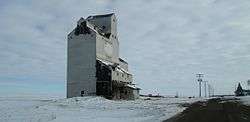
Grain elevator in Simmie | |
 Location of Simmie in Saskatchewan | |
| Coordinates: 49°53′46″N 108°14′10″W / 49.896°N 108.236°W | |
| Country | Canada |
| Province | Saskatchewan |
| Region | Southwest Saskatchewan |
| Census division | 4 |
| Rural Municipality | Bone Creek |
| Government | |
| • Governing body | Bone Creek No. 108 |
| Area | |
| • Land | 0.12 km2 (0.05 sq mi) |
| Population (2006) | |
| • Total | 15 |
| • Density | 127.3/km2 (330/sq mi) |
| Time zone | CST |
| Postal Code | S0N 2M0 |
| Area code(s) | 306 |
| Highways |
Highway 343 Highway 631 |
| Waterways | Reid Lake |
| [1][2][3][4] | |
Simmie is a hamlet in Bone Creek Rural Municipality No. 108, Saskatchewan, Canada. Listed as a designated place by Statistics Canada, the hamlet had a population of 15 in the Canada 2006 Census.[5] The hamlet is located on Highway 343 and Highway 631, about km southwest of Swift Current.
Demographics
In 2006, Simmie had a population of 15 living in 14 dwellings, a 50.0% increase from 2001. The hamlet had a land area of 0.12 km2 (0.046 sq mi) and a population density of 127.3/km2 (330/sq mi).[6]
See also
References
- ↑ National Archives, Archivia Net, Post Offices and Postmasters
- ↑ Government of Saskatchewan, MRD Home, Municipal Directory System, archived from the original (– Scholar search) on November 21, 2008
- ↑ Canadian Textiles Institute. (2005), CTI Determine your provincial constituency
- ↑ Commissioner of Canada Elections, Chief Electoral Officer of Canada (2005), Elections Canada On-line
- ↑ Canada 2006 Census: Designated places in Saskatchewan
- ↑ Statistics Canada. "Canada 2006 Census: Simmie - Community Profile". Retrieved 2009-01-15.
External links
- Saskatchewan City & Town Maps
- Saskatchewan Gen Web - One Room School Project
- Post Offices and Postmasters - ArchiviaNet - Library and Archives Canada
- Saskatchewan Gen Web Region
- Online Historical Map Digitization Project
- GeoNames Query
- 2006 Community Profiles
 |
Gull Lake | Webb | Beverley | |
| Cypress Hills | |
Neville | ||
| ||||
| | ||||
| Shaunavon | Scotsguard | Admiral |
| Subdivisions | |
|---|---|
| Communities | |
| Cities | |
| Topics |
|
| |
Coordinates: 49°56′38″N 108°06′22″W / 49.94389°N 108.10611°W
This article is issued from Wikipedia - version of the 9/10/2016. The text is available under the Creative Commons Attribution/Share Alike but additional terms may apply for the media files.