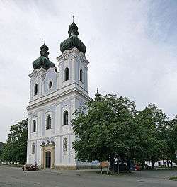
Sloup (Blansko District)
| Sloup | |||
|---|---|---|---|
| Městys | |||
 | |||
| |||
 Sloup | |||
| Coordinates: 49°25′17″N 16°44′26″E / 49.42139°N 16.74056°ECoordinates: 49°25′17″N 16°44′26″E / 49.42139°N 16.74056°E | |||
| Country |
| ||
| Region | South Moravian | ||
| District | Blansko | ||
| Area | |||
| • Total | 7.64 km2 (2.95 sq mi) | ||
| Elevation | 471 m (1,545 ft) | ||
| Population (2012) | |||
| • Total | 962 | ||
| • Density | 130/km2 (330/sq mi) | ||
| Postal code | 679 13 | ||
| Website | http://www.sloup.info/ | ||

Sloup is a small town (městys) in Blansko District in the South Moravian Region of the Czech Republic.
The town covers an area of 7.64 square kilometres (2.95 sq mi), and has a population of 902 (as at 28 August 2006).
Sloup lies approximately 9 kilometres (6 mi) north-east of Blansko, 27 km (17 mi) north of Brno, and 183 km (114 mi) south-east of Prague.
Approximately 0,7 miles from Sloup, Sloupsko-šošůvské caves are located, with Kůlna – the cave that became a remarkable European Paleolithic site since the 1880s.
References
This article is issued from Wikipedia - version of the 5/16/2016. The text is available under the Creative Commons Attribution/Share Alike but additional terms may apply for the media files.