Sover
| Sover Soér | |
|---|---|
| Comune | |
| Comune di Sover | |
 Sover Location of Sover in Italy | |
| Coordinates: 46°13′N 11°19′E / 46.217°N 11.317°ECoordinates: 46°13′N 11°19′E / 46.217°N 11.317°E | |
| Country | Italy |
| Region | Trentino-Alto Adige/Südtirol |
| Province / Metropolitan city | Trentino (TN) |
| Frazioni | Montesover, Piscine, Facendi, Piazzoli, Sveseri, Settefontane, Molini, Slosseri, Baiti, Montalto, Fraine, Marigiàt |
| Area | |
| • Total | 14.7 km2 (5.7 sq mi) |
| Elevation | 854 m (2,802 ft) |
| Population (Dec. 2004) | |
| • Total | 921 |
| • Density | 63/km2 (160/sq mi) |
| Demonym(s) | Soeri |
| Time zone | CET (UTC+1) |
| • Summer (DST) | CEST (UTC+2) |
| Postal code | 38048 |
| Dialing code | 0461 |
| Patron saint | S.Lorenzo martire |
| Website | http://www.comunesover.tn.it/ |
Sover (German: Sofer) is a comune (municipality) in Trentino in the northern Italian region Trentino-Alto Adige/Südtirol, located about 25 kilometres (16 mi) northeast of Trento.
Geography
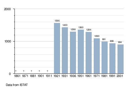
As of 31 December 2004, it had a population of 921 and an area of 14.7 square kilometres (5.7 sq mi).[1]
The municipality of Sover contains the frazioni (subdivisions, mainly villages and hamlets) Montesover, Piscine, Facendi, Piazzoli, Sveseri and Settefontane.
Sover borders the following municipalities: Capriana, Valfloriana, Grauno, Grumes, Segonzano, Lona-Lases and Bedollo.
Demographic evolution
References

This article is issued from Wikipedia - version of the 1/31/2015. The text is available under the Creative Commons Attribution/Share Alike but additional terms may apply for the media files.