Stagno Lombardo
| Stagno Lombardo | |
|---|---|
| Comune | |
| Comune di Stagno Lombardo | |
 Stagno Lombardo Location of Stagno Lombardo in Italy | |
| Coordinates: 45°4′N 10°5′E / 45.067°N 10.083°ECoordinates: 45°4′N 10°5′E / 45.067°N 10.083°E | |
| Country | Italy |
| Region | Lombardy |
| Province / Metropolitan city | Province of Cremona (CR) |
| Frazioni | Brancere, Forcello, Straconcolo |
| Area | |
| • Total | 39.9 km2 (15.4 sq mi) |
| Population (Dec. 2004) | |
| • Total | 1,456 |
| • Density | 36/km2 (95/sq mi) |
| Time zone | CET (UTC+1) |
| • Summer (DST) | CEST (UTC+2) |
| Postal code | 26049 |
| Dialing code | 0372 |
| Website | Official website |
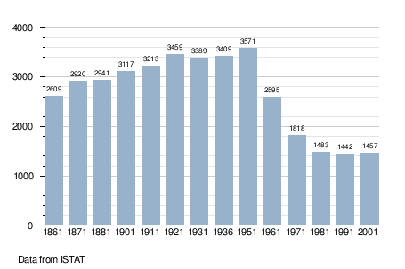
Stagno Lombardo is a comune (municipality) in the Province of Cremona in the Italian region Lombardy, located about 80 kilometres (50 mi) southeast of Milan and about 8 kilometres (5 mi) southeast of Cremona. As of 31 December 2004, it had a population of 1,456 and an area of 39.9 square kilometres (15.4 sq mi).[1]
The municipality of Stagno Lombardo contains the frazioni (subdivisions, mainly villages and hamlets) Brancere, Forcello, and Straconcolo.
Stagno Lombardo borders the following municipalities: Bonemerse, Castelvetro Piacentino, Cremona, Gerre de' Caprioli, Pieve d'Olmi, Polesine Parmense, Villanova sull'Arda, Zibello.
Demographic evolution
References
External links
This article is issued from Wikipedia - version of the 1/31/2015. The text is available under the Creative Commons Attribution/Share Alike but additional terms may apply for the media files.