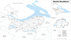
Steckborn District
| Steckborn District Bezirk Steckborn | |
|---|---|
| District | |
 | |
| Country |
|
| Canton |
|
| Capital | Steckborn |
| Area | |
| • Total | 132.9 km2 (51.3 sq mi) |
| Population (2009) | |
| • Total | 18,215 |
| • Density | 140/km2 (350/sq mi) |
| Time zone | CET (UTC+1) |
| • Summer (DST) | CEST (UTC+2) |
| Municipalities | 15 |
Steckborn District is a former district of the canton of Thurgau, Switzerland. It had a population of 18,215 (as of 2009).[1] Its capital was the town of Steckborn.
The former district contained the following municipalities:
| Coat of arms | Municipality | Population (31 December 2015)[2] |
Area km²[3] |
|---|---|---|---|
| | Berlingen | 861 | 4.0 |
| | Eschenz | 1,725 | 12.0 |
| | Herdern | 1,020 | 13.7 |
| | Homburg | 1,512 | 24.1 |
| | Hüttwilen | 1,669 | 17.6 |
| | Mammern | 626 | 5.5 |
| | Müllheim | 2,884 | 8.7 |
| | Pfyn | 1,941 | 13.0 |
| | Raperswilen | 395 | 7.7 |
| | Salenstein | 1,282 | 6.6 |
| | Steckborn | 3,726 | 8.8 |
| | Wagenhausen | 1,674 | 11.2 |
| Total | 18,215 | 132.9 |
References
- ↑ Swiss Federal Statistical Office - STAT-TAB, online database – Ständige und nichtständige Wohnbevölkerung nach institutionellen Gliederungen, Geburtsort und Staatsangehörigkeit (German) accessed 30 August 2016
- ↑ Swiss Federal Statistical Office - STAT-TAB, online database – Ständige und nichtständige Wohnbevölkerung nach institutionellen Gliederungen, Geburtsort und Staatsangehörigkeit (German) accessed 30 August 2016
- ↑ Swiss Federal Statistical Office-Land Use Statistics 2009 data (German) accessed 25 March 2010
Coordinates: 47°40′N 8°59′E / 47.667°N 8.983°E
This article is issued from Wikipedia - version of the 6/21/2013. The text is available under the Creative Commons Attribution/Share Alike but additional terms may apply for the media files.