Sterkspruit
| Sterkspruit | |
|---|---|
|
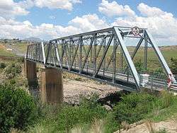
Bridge over the Orange River near Sterkspruit | |
 Sterkspruit  Sterkspruit  Sterkspruit
| |
| Coordinates: 30°31′26″S 27°22′12″E / 30.524°S 27.370°ECoordinates: 30°31′26″S 27°22′12″E / 30.524°S 27.370°E | |
| Country | South Africa |
| Province | Eastern Cape |
| District | Joe Gqabi |
| Municipality | Senqu |
| Area[1] | |
| • Total | 4.02 km2 (1.55 sq mi) |
| Population (2011)[1] | |
| • Total | 1,893 |
| • Density | 470/km2 (1,200/sq mi) |
| Racial makeup (2011)[1] | |
| • Black African | 96.2% |
| • Coloured | 0.9% |
| • Indian/Asian | 2.1% |
| • White | 0.4% |
| • Other | 0.4% |
| First languages (2011)[1] | |
| • Xhosa | 73.5% |
| • Sotho | 14.2% |
| • English | 4.3% |
| • Afrikaans | 1.0% |
| • Other | 7.0% |
| Postal code (street) | 9762 |
| PO box | 9762 |
| Area code | 051 |
Sterkspruit is a town in Joe Gqabi District Municipality in the Eastern Cape province of South Africa.
The town is located about 45 km south-east of Zastron, 80 km north-east of Aliwal North, and 24 km from the Lesotho border.[2] It takes its name from the Sterkspruit, the watercourse on which it is situated. The name is Afrikaans and means ‘strong stream’.[3]
Besides the assortment of shops and many businesses to be found in town, it also houses the Empilisweni District Hospital, a public government funded and managed district hospital. It is a level 1 hospital with 93 usable beds. As it is situated close to the Lesotho and Free State borders, it also renders health services to cross-border citizens visiting Sterkspruit.
References
- 1 2 3 4 "Main Place Sterkspruit". Census 2011.
- ↑ http://www.saexplorer.co.za/south-africa/distance/sterkspruit_distance.asp
- ↑ "Dictionary of Southern African Place Names (Public Domain)". Human Science Research Council. p. 416.
Municipalities and communities of Joe Gqabi District Municipality, Eastern Cape | ||
|---|---|---|
District seat: Barkly East | ||
| Elundini | .svg.png) | |
| Senqu | ||
| Maletswai | ||
| Gariep | ||
 |
Rouxville | Zastron | Palmietfontein | |
| Orange River | |
Tele Bridge, Kingdom of Lesotho | ||
| ||||
| | ||||
| Aliwal North | Herschel | Lady Grey 45 km |