Stour Row
| Stour Row | |
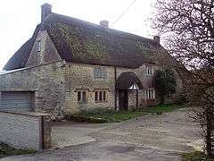 Sweet's House, Stour Row |
|
 Stour Row |
|
| OS grid reference | ST822211 |
|---|---|
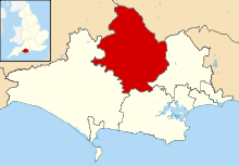
| District | North Dorset |
| Shire county | Dorset |
| Region | South West |
| Country | England |
| Sovereign state | United Kingdom |
| Police | Dorset |
| Fire | Dorset and Wiltshire |
| Ambulance | South Western |
| EU Parliament | South West England |
Coordinates: 50°59′22″N 2°15′17″W / 50.9895°N 2.2546°W
Stour Row is a village in north Dorset, England, situated beside Duncliffe Hill 3 miles (4.8 km) southwest of Shaftesbury. It lies within the parish of the neighbouring village of Stour Provost.[1] Stour Row has few amenities, but did have a petrol station, pub and shop prior to the early 1980s. It has a church, All Saints, which was built in 1868.[1] It lies within the SP7 postcode area. There used to be a pub, now found to be closed.
References
- 1 2 "Stour Provost including Stour Row". Dorset OPC Project. Retrieved 27 November 2013.
External links
![]() Media related to Stour Row at Wikimedia Commons
Media related to Stour Row at Wikimedia Commons
This article is issued from Wikipedia - version of the 10/3/2016. The text is available under the Creative Commons Attribution/Share Alike but additional terms may apply for the media files.