Tafa
For other uses, see Tafa (disambiguation).
| Tafa | |
|---|---|
| LGA | |
 Tafa Location in Nigeria | |
| Coordinates: 9°15′N 7°15′E / 9.250°N 7.250°ECoordinates: 9°15′N 7°15′E / 9.250°N 7.250°E | |
| Country |
|
| State | Niger State |
| Government | |
| • Local Government Chairman and the Head of the Local Government Council | Samuel B. Gwomna |
| Area | |
| • Total | 222 km2 (86 sq mi) |
| Population (2006 census) | |
| • Total | 83,544 |
| Time zone | WAT (UTC+1) |
| 3-digit postal code prefix | 910 |
| ISO 3166 code | NG.NI.TA |
Tafa is a Local Government Area in Niger State, Nigeria, adjoining the Federal Capital Territory. Its headquarters are in the town of Wuse.
It has an area of 222 km² and a population of 83,544 at the 2006 census.
The postal code of the area is 910.[1]
References
- ↑ "Post Offices- with map of LGA". NIPOST. Retrieved 2009-10-20.
State capital: Minna | ||
| LGAs | 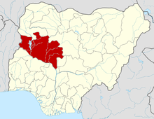 | |
This article is issued from Wikipedia - version of the 6/27/2015. The text is available under the Creative Commons Attribution/Share Alike but additional terms may apply for the media files.