Tavernette
| Tavernette | |
|---|---|
| Frazione | |
|
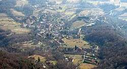
Panoramic view from Rocca Due Denti | |
 Tavernette Location of Tavernette in Italy | |
| Coordinates: IT 44°57′09″N 7°22′27″E / 44.95250°N 7.37417°ECoordinates: IT 44°57′09″N 7°22′27″E / 44.95250°N 7.37417°E | |
| Country |
|
| Region |
|
| Province | Turin (TO) |
| Comune | Cumiana |
| Elevation | 374 m (1,227 ft) |
| Population (2001)[1] | |
| • Total | 236 |
| Demonym(s) | |
| Time zone | CET (UTC+1) |
| • Summer (DST) | CEST (UTC+2) |
| Postal code | 100400 |
| Dialing code | (+39) 011 |
Tavernette is a frazione (neighbourhood) of Cumiana, in Piedmont, northern Italy.
Its name comes from the latin tabernae [2] (in English tavern or country pub).
Geography
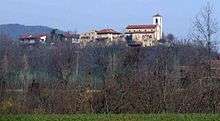
San Pietro in Vincoli parish church
It is a borough located in the Chisola Valley, in the easternmost part of Cottian Alps, some kilometers south-east from the centre of Cumiana. The Monte Tre Denti and Monte Freidour peaks are located nearby.
History
Since 1928 Tavernette was a separate comune (municipality); before 1801 it also encompassed the present-day municipality of Piscina, located in the Po plain.[3]
| Wikimedia Commons has media related to Tavernette. |
References
- ↑ 14° Censimento generale della popolazione e delle abitazioni, Istat website dawinci.istat.it (accessed on February 2013)
- ↑ AA.VV (2010). Monte Tre Denti Freidour. Torino: Hapax. p. 10.
- ↑ Una briciola di ... storia..., Piscina municipality web site http://www.comune.piscina.to.it/articles.asp?id=2 (accessed on February 2013)
This article is issued from Wikipedia - version of the 7/12/2016. The text is available under the Creative Commons Attribution/Share Alike but additional terms may apply for the media files.