Teddy Bear, South Dakota
| Teddy Bear | |
|---|---|
| Ghost town | |
 Teddy Bear Location in South Dakota | |
| Coordinates: 43°57′05″N 103°30′22″W / 43.95139°N 103.50611°WCoordinates: 43°57′05″N 103°30′22″W / 43.95139°N 103.50611°W | |
| Country | United States |
| State | South Dakota |
| County | Pennington |
| Elevation | 4,770 ft (1,450 m) |
| Time zone | Mountain (MST) (UTC-7) |
| • Summer (DST) | MDT (UTC-6) |
| GNIS feature ID | 1264576[1] |
Teddy Bear is a ghost town in Pennington County, South Dakota.[1]
The settlement was located 3.5 mi (5.6 km) east of Hill City.
References
Municipalities and communities of Pennington County, South Dakota, United States | ||
|---|---|---|
| Cities | 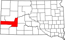 | |
| Towns | ||
| CDPs | ||
| Other unincorporated communities | ||
| Ghost towns | ||
| Footnotes | ‡This populated place also has portions in an adjacent county or counties | |
This article is issued from Wikipedia - version of the 10/16/2016. The text is available under the Creative Commons Attribution/Share Alike but additional terms may apply for the media files.