Texas State Highway 275
| ||||
|---|---|---|---|---|
| Harborside Drive | ||||
 | ||||
| Route information | ||||
| Maintained by TxDOT | ||||
| Length: | 6.225 mi[1] (10.018 km) | |||
| Existed: | 1993 – present | |||
| Major junctions | ||||
| West end: |
| |||
| East end: |
| |||
| Highway system | ||||
| ||||

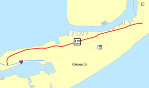
State Highway 275 or SH 275 is a Texas state highway running along the northern side of Galveston Island from Interstate 45 to SH 87.
Route description
SH 275 begins at a junction with I-45 in Galveston. It initially heads north, but turns towards the east as it heads through Galveston. SH 275 reaches its eastern terminus at a junction with SH 87 in Galveston. The highway is also known as Harborside Drive.
History
SH 275 was originally designated in 1938 on a route from Mabelle to Jimtown. This was cancelled in 1943. The current route was designated in 1993.
Major junctions
The entire route is in Galveston, Galveston County.
| mi | km | Destinations | Notes | ||
|---|---|---|---|---|---|
| 0.000 | 0.000 | I-45 exit 1C | |||
| 6.225 | 10.018 | ||||
| 1.000 mi = 1.609 km; 1.000 km = 0.621 mi | |||||
References
- ↑ Transportation Planning and Programming Division (n.d.). "State Highway No. 275". Highway Designation Files. Texas Department of Transportation. Retrieved 2010-11-03.
This article is issued from Wikipedia - version of the 7/31/2016. The text is available under the Creative Commons Attribution/Share Alike but additional terms may apply for the media files.