Tha Wang Pha District
| Tha Wang Pha ท่าวังผา | |
|---|---|
| Amphoe | |
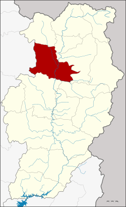 Amphoe location in Nan Province | |
| Coordinates: 19°7′11″N 100°48′35″E / 19.11972°N 100.80972°ECoordinates: 19°7′11″N 100°48′35″E / 19.11972°N 100.80972°E | |
| Country |
|
| Province | Nan |
| Government | |
| • Marshal | Manat Kansai |
| Area | |
| • Total | 702.204 km2 (271.122 sq mi) |
| Population (2009) | |
| • Total | 51,518 |
| • Density | 73/km2 (190/sq mi) |
| Time zone | THA (UTC+7) |
| Postal code | 55140 |
| Geocode | 5506 |
Tha Wang Pha (Thai: ท่าวังผา, pronounced [tʰâː wāŋ pʰǎː]) is a district (Amphoe) in the central part of Nan Province, northern Thailand.
History
The minor district (King Amphoe) Tha Wang Pha was established on October 1, 1962 with area split off from Pua district.[1] It was upgraded to a full district on July 28, 1965.[2]
Geography
Neighboring are from the north clockwise Song Khwae, Chiang Klang, Pua, Santi Suk and Mueang Nan of Nan Province, and Pong of Phayao Province.
Climate
| Climate data for Tha Wang Pha (1981–2010) | |||||||||||||
|---|---|---|---|---|---|---|---|---|---|---|---|---|---|
| Month | Jan | Feb | Mar | Apr | May | Jun | Jul | Aug | Sep | Oct | Nov | Dec | Year |
| Record high °C (°F) | 34.8 (94.6) |
37.6 (99.7) |
40.2 (104.4) |
42.5 (108.5) |
41.4 (106.5) |
39.5 (103.1) |
37.3 (99.1) |
36.7 (98.1) |
34.9 (94.8) |
35.9 (96.6) |
34.3 (93.7) |
33.8 (92.8) |
42.5 (108.5) |
| Average high °C (°F) | 29.4 (84.9) |
32.4 (90.3) |
35.3 (95.5) |
36.2 (97.2) |
34.0 (93.2) |
32.4 (90.3) |
31.3 (88.3) |
31.1 (88) |
31.9 (89.4) |
31.5 (88.7) |
29.9 (85.8) |
28.3 (82.9) |
32.0 (89.6) |
| Daily mean °C (°F) | 20.6 (69.1) |
22.4 (72.3) |
25.9 (78.6) |
28.3 (82.9) |
28.1 (82.6) |
27.9 (82.2) |
27.2 (81) |
26.9 (80.4) |
26.8 (80.2) |
25.8 (78.4) |
23.1 (73.6) |
20.5 (68.9) |
25.3 (77.5) |
| Average low °C (°F) | 13.4 (56.1) |
14.6 (58.3) |
18.3 (64.9) |
21.9 (71.4) |
23.6 (74.5) |
24.2 (75.6) |
23.9 (75) |
23.7 (74.7) |
23.3 (73.9) |
21.7 (71.1) |
17.9 (64.2) |
13.9 (57) |
20.0 (68) |
| Record low °C (°F) | 6.5 (43.7) |
5.4 (41.7) |
7.2 (45) |
15.3 (59.5) |
18.4 (65.1) |
19.6 (67.3) |
19.7 (67.5) |
19.8 (67.6) |
18.0 (64.4) |
12.0 (53.6) |
6.2 (43.2) |
1.7 (35.1) |
1.7 (35.1) |
| Average rainfall mm (inches) | 7.0 (0.276) |
9.0 (0.354) |
33.5 (1.319) |
102.5 (4.035) |
183.0 (7.205) |
173.4 (6.827) |
268.4 (10.567) |
297.8 (11.724) |
211.5 (8.327) |
83.4 (3.283) |
27.6 (1.087) |
11.0 (0.433) |
1,408.1 (55.437) |
| Average rainy days | 1.4 | 1.7 | 4.0 | 10.1 | 17.6 | 18.8 | 22.1 | 23.0 | 17.8 | 10.5 | 4.2 | 1.4 | 132.6 |
| Average relative humidity (%) | 78 | 73 | 68 | 70 | 78 | 82 | 84 | 86 | 85 | 84 | 81 | 80 | 79 |
| Mean monthly sunshine hours | 288.3 | 271.2 | 313.1 | 243.0 | 198.4 | 117.0 | 120.9 | 58.9 | 144.0 | 198.4 | 249.0 | 269.7 | 2,471.9 |
| Mean daily sunshine hours | 9.3 | 9.6 | 10.1 | 8.1 | 6.4 | 3.9 | 3.9 | 1.9 | 4.8 | 6.4 | 8.3 | 8.7 | 6.8 |
| Source #1: Thai Meteorological Department[3] | |||||||||||||
| Source #2: Office of Water Management and Hydrology, Royal Irrigation Department (sun and humidity)[4] | |||||||||||||
Administration
The district is subdivided into 10 subdistricts (tambon), which are further subdivided into 91 villages (muban). Tha Wang Pha is a township (thesaban tambon) covering parts of the same-named tambon. There are further 9 Tambon administrative organizations (TAO).
| No. | Name | Thai name | Villages | Inh. | |
|---|---|---|---|---|---|
| 1. | Rim | ริม | 6 | 4,325 | |
| 2. | Pa Kha | ป่าคา | 7 | 5,117 | |
| 3. | Pha To | ผาตอ | 7 | 5,120 | |
| 4. | Yom | ยม | 10 | 4,900 | |
| 5. | Tan Chum | ตาลชุม | 14 | 6,672 | |
| 6. | Si Phum | ศรีภูมิ | 12 | 6,766 | |
| 7. | Chom Phra | จอมพระ | 11 | 5,465 | |
| 8. | Saen Thong | แสนทอง | 8 | 3,948 | |
| 9. | Tha Wang Pha | ท่าวังผา | 8 | 5,663 | |
| 10. | Pha Thong | ผาทอง | 8 | 4,074 |
Gallery
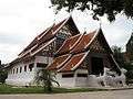 Wat Nong Bua exterior in Amphoe Tha Wang Pha
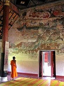 Wat Nong Bua interior in Amphoe Tha Wang Pha
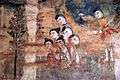 19th Century temple murals in Thai Lue style from Wat Nong Bua
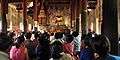 Family and friends congregate when a young boy enters monkhood at Wat Nong Bua
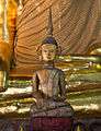 A small, wooden Thai Lue Buddha statue inside Wat Nong Bua
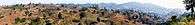 Panorama of the eastern flank of the Phi Pan Nam Range
References
- ↑ ประกาศกระทรวงมหาดไทย เรื่อง แบ่งท้องที่ตั้งเป็นกิ่งอำเภอ (PDF). Royal Gazette (in Thai). 79 (90 ง): 2097–2098. October 2, 1962.
- ↑ พระราชกฤษฎีกาตั้งอำเภอศรีสวัสดิ์ อำเภอสังขละบุรี อำเภอท่าคันโท อำเภอดอกคำใต้ อำเภอแม่ใจ อำเภอจุน อำเภอขามทะเลสอ อำเภอไพศาลี อำเภอท่าวังผา อำเภอบ้านกรวด อำเภอเด่นชัย อำเภอปทุมรัตต์ อำเภอกะเปอร์ อำเภออากาศอำนวย อำเภอดอนเจดีย์ อำเภอจอมพระ และอำเภอสามโก้ พ.ศ. ๒๕๐๘ (PDF). Royal Gazette (in Thai). 81 (49 ก): 565–569. July 27, 1965.
- ↑ "Climatological Data for the Period 1981–2010". Thai Meteorological Department. p. 4. Retrieved 31 July 2016.
- ↑ "ปริมาณการใช้น้ำของพืชอ้างอิงโดยวิธีของ Penman Monteith (Reference Crop Evapotranspiration by Penman Monteith)" (PDF) (in Thai). Office of Water Management and Hydrology, Royal Irrigation Department. p. 24. Retrieved 31 July 2016.
External links
This article is issued from Wikipedia - version of the 8/1/2016. The text is available under the Creative Commons Attribution/Share Alike but additional terms may apply for the media files.