Third Schafalpenkopf
| Third Schafalpenkopf | |
|---|---|
|
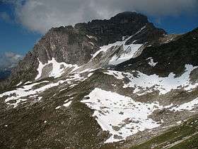
From the northeast over the Saubuckeln | |
| Highest point | |
| Elevation | 2,320 m above sea level (NHN) (7,610 ft) |
| Prominence | 216 m ↓ Kemptner Scharte |
| Isolation | 2.9 km → Elfer |
| Coordinates | 47°18′37″N 10°13′00″E / 47.31028°N 10.21667°ECoordinates: 47°18′37″N 10°13′00″E / 47.31028°N 10.21667°E |
| Geography | |
| Parent range | Southeastern Walsertal Mountains, Allgäuer Alpen |
| Geology | |
| Mountain type | main dolomite |
| Climbing | |
| Normal route | Mindelheim Klettersteig |
The Third Schafalpenkopf (German: Dritte Schafalpenkopf), Highest Schafalpenkopf (Höchster Schafalpenkopf) or Northeastern Schafalpenkopf (Nordöstlicher Schafalpenkopf) is a 2,320-metre-high mountain in the Allgäu Alps. It is part of the Mindelheimer Klettersteig.
Gallery
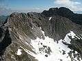 From the southwest with the Großer Wanne
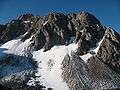 From the Fiderepass Hut
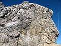 Klettersteig entrance
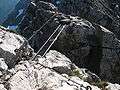 Ladder bridge at the summit
References
External links
| Wikimedia Commons has media related to Dritter Schafalpenkopf. |
This article is issued from Wikipedia - version of the 12/20/2015. The text is available under the Creative Commons Attribution/Share Alike but additional terms may apply for the media files.