Tolminske Ravne
| Tolminske Ravne | |
|---|---|
 | |
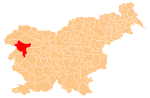
 Tolminske Ravne Location in Slovenia | |
| Coordinates: 46°13′45.24″N 13°46′14.57″E / 46.2292333°N 13.7707139°ECoordinates: 46°13′45.24″N 13°46′14.57″E / 46.2292333°N 13.7707139°E | |
| Country |
|
| Traditional region | Slovenian Littoral |
| Statistical region | Gorizia |
| Municipality | Tolmin |
| Area | |
| • Total | 13.83 km2 (5.34 sq mi) |
| Elevation | 913 m (2,995 ft) |
| Population (2002) | |
| • Total | 13 |
| [1] | |
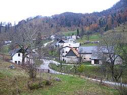
Tolminske Ravne (pronounced [tɔlˈmiːnskɛ ˈɾaːu̯nɛ]) is a small settlement high in the hills northeast of Tolmin in the Littoral region of Slovenia.[2] It lies within the boundaries of Triglav National Park.
References
External links
-
 Media related to Tolminske Ravne at Wikimedia Commons
 - Tolminske Ravne on Geopedia
This article is issued from Wikipedia - version of the 7/11/2016. The text is available under the Creative Commons Attribution/Share Alike but additional terms may apply for the media files.