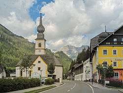
Tweng
| Tweng | |
|---|---|
 | |
 Tweng Location within Austria | |
| Coordinates: 47°11′28″N 13°36′01″E / 47.19111°N 13.60028°ECoordinates: 47°11′28″N 13°36′01″E / 47.19111°N 13.60028°E | |
| Country | Austria |
| State | Salzburg |
| District | Tamsweg |
| Government | |
| • Mayor | Friedrich Rigele (ÖVP) |
| Area | |
| • Total | 86.54 km2 (33.41 sq mi) |
| Elevation | 1,233 m (4,045 ft) |
| Population (1 January 2016)[1] | |
| • Total | 282 |
| • Density | 3.3/km2 (8.4/sq mi) |
| Time zone | CET (UTC+1) |
| • Summer (DST) | CEST (UTC+2) |
| Postal code | 5563 |
| Area code | 06471 |
| Vehicle registration | TA |
| Website | www.tweng.at |
Tweng is a municipality in the district of Tamsweg in the state of Salzburg in Austria.
Geography
Tweng lies in the Lungau on the south side of the Radstädter Tauern.
References
Gallery
 between Vorder and Mauterndorf, panorama
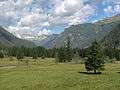 between Vorder and Mauterndorf, panorama
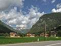 Vorder, view to the village
This article is issued from Wikipedia - version of the 10/20/2016. The text is available under the Creative Commons Attribution/Share Alike but additional terms may apply for the media files.