Vésztő
| Vésztő | ||
|---|---|---|
|
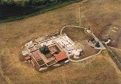
Vésztő, Csolt Monastery | ||
| ||
 Vésztő | ||
| Coordinates: 46°55′26″N 21°15′43″E / 46.924°N 21.262°ECoordinates: 46°55′26″N 21°15′43″E / 46.924°N 21.262°E | ||
| Country |
| |
| County | Békés | |
| Area | ||
| • Total | 125.76 km2 (48.56 sq mi) | |
| Population (2015) | ||
| • Total | 6,855[1] | |
| • Density | 54.5/km2 (141/sq mi) | |
| Time zone | CET (UTC+1) | |
| • Summer (DST) | CEST (UTC+2) | |
| Postal code | 5530 | |
| Area code(s) | 66 | |

Vésztő is a town in Békés county, in the Southern Great Plain region of south-east Hungary.
Geography
It covers an area of 125.76 km² and has a population of 6855 people (2015).[1] The town is situated in the Tisza plain.
History
North of the modern town there is the archaeological site of a neolithic tell. At its top the medieval Csolt monastery is located.
Twin towns – Sister cities
Vésztő is twinned with:
References
- 1 2 Gazetteer of Hungary, 1st January 2015. Hungarian Central Statistical Office. 03/09/2015
County seat: Békéscsaba | ||
| Cities and towns | 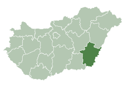 | |
| Villages |
| |
| Other topics |
| |
This article is issued from Wikipedia - version of the 5/16/2016. The text is available under the Creative Commons Attribution/Share Alike but additional terms may apply for the media files.