Vracov
| Vracov | ||
|---|---|---|
| Town | ||
|
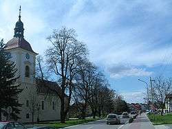
Main street and the Saint Lawrence Church | ||
| ||
 Vracov | ||
| Coordinates: 48°58′47″N 17°13′6″E / 48.97972°N 17.21833°ECoordinates: 48°58′47″N 17°13′6″E / 48.97972°N 17.21833°E | ||
| Country |
| |
| Region | South Moravian | |
| District | Hodonín | |
| Area | ||
| • Total | 44.50 km2 (17.18 sq mi) | |
| Elevation | 183 m (600 ft) | |
| Population (2012) | ||
| • Total | 4,560 | |
| • Density | 100/km2 (270/sq mi) | |
| Postal code | 696 42 | |
| Website | http://www.vracov.com/ | |
Vracov (Czech pronunciation: [ˈvratsof]) is a town in the South Moravian Region, Czech Republic. It has a population of around 4500 people.
External links
- Official website (Czech)
| Wikimedia Commons has media related to Vracov. |
This article is issued from Wikipedia - version of the 4/4/2016. The text is available under the Creative Commons Attribution/Share Alike but additional terms may apply for the media files.