Wharram railway station
| Wharram | |
|---|---|
|
The former station at Wharram | |
| Location | |
| Place | Wharram-le-Street |
| Area | Ryedale |
| Coordinates | 54°04′37″N 0°41′22″W / 54.076930°N 0.689380°WCoordinates: 54°04′37″N 0°41′22″W / 54.076930°N 0.689380°W |
| Grid reference | SE858653 |
| Operations | |
| Original company | Malton and Driffield Railway |
| Pre-grouping | North Eastern Railway |
| Post-grouping | London and North Eastern Railway |
| Platforms | 1 |
| History | |
| 1853 | Opened |
| 1950 | Closed |
| Disused railway stations in the United Kingdom | |
|
Closed railway stations in Britain A B C D–F G H–J K–L M–O P–R S T–V W–Z | |
|
| |

Wharram railway station (SE858653) was a railway station on the Malton and Driffield Railway. It opened on 19 May 1853, and served the village of Wharram-le-Street in North Yorkshire, England. It closed on 5 June 1950. The station was also sited near the deserted medieval village of Wharram Percy as well as being adjacent to a chalk quarry.
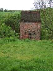
The water tower at Wharram station
References
- Butt, R. V. J. (1995). The Directory of Railway Stations: details every public and private passenger station, halt, platform and stopping place, past and present (1st ed.). Sparkford: Patrick Stephens Ltd. ISBN 1-8526-0508-1. OCLC 60251199.
- "Station Name: Wharram". Disused Stations. Subterranea Britannica. 2 July 2010. Retrieved 10 December 2011.
External links
- Wharram station on navigable 1947 O. S. map
- "Wharram Station". Yorkshire Wolds Railway Restoration Project.
| Preceding station | Disused railways | Following station | ||
|---|---|---|---|---|
| North Grimston | Malton and Driffield Railway | Burdale | ||
This article is issued from Wikipedia - version of the 7/6/2014. The text is available under the Creative Commons Attribution/Share Alike but additional terms may apply for the media files.