Agua Linda, Arizona
| Agua Linda, Arizona | |
|---|---|
| Populated place | |
 Agua Linda, Arizona Location of Agua Linda in Arizona | |
| Coordinates: 31°40′44″N 111°03′42″W / 31.67889°N 111.06167°WCoordinates: 31°40′44″N 111°03′42″W / 31.67889°N 111.06167°W | |
| Country | United States |
| State | Arizona |
| County | Santa Cruz |
| Elevation[1] | 3,113 ft (949 m) |
| Time zone | Mountain (MST) (UTC-7) |
| • Summer (DST) | MST (UTC-7) |
| ZIP codes | 85645 |
| Area code(s) | 520 |
| FIPS code | 04-00660 |
| GNIS feature ID | 25543 |
Agua Linda is a populated place situated in the Amado CDP, located in Santa Cruz County, Arizona.[2] It has an estimated elevation of 3,113 feet (949 m) above sea level.
See also
References
- ↑ "Feature Detail Report for: Agua Linda". Geographic Names Information System. United States Geological Survey.
- ↑ "Agua Linda (in Santa Cruz County, AZ) Populated Place Profile". AZ Hometown Locator. Retrieved December 11, 2015.
Municipalities and communities of Santa Cruz County, Arizona, United States | ||
|---|---|---|
| City | 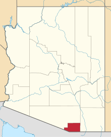 | |
| Town | ||
| CDPs | ||
| Unincorporated communities | ||
| Ghost towns | ||
This article is issued from Wikipedia - version of the 7/12/2016. The text is available under the Creative Commons Attribution/Share Alike but additional terms may apply for the media files.