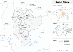
Albula District
| Albula District Bezirk Albula District Alvra Distretto di Albula | |
|---|---|
| District | |
 | |
| Country |
|
| Canton |
|
| Capital | Tiefencastel |
| Area | |
| • Total | 693.47 km2 (267.75 sq mi) |
| Population (2015) | |
| • Total | 8,210 |
| • Density | 12/km2 (31/sq mi) |
| Time zone | CET (UTC+1) |
| • Summer (DST) | CEST (UTC+2) |
| Municipalities | 8 |
Albula District is one of the eleven administrative districts in the canton of Graubünden in Switzerland. It has an area of 723.13 km² and has a population of 8,210 (as of 31 December 2015).[1]
Albula District consists of four Kreise (sub-districts) Alvaschein, Belfort, Bergün and Surses, which are formed from a total of 8 municipalities following mergers in 2015 and 2016.
| Alvaschein sub-district | ||||
|---|---|---|---|---|
| Municipality | Population (31 December 2015)[1] |
Area (km²) | ||
| Albula/Alvra | 1,331 | 93.93 | ||
| Mutten | 72 | 9.9 | ||
| Vaz/Obervaz | 2,718 | 42.51 | ||
| Belfort sub-district | ||||
|---|---|---|---|---|
| Municipality | Population (31 December 2015)[1] |
Area (km²) | ||
| Lantsch/Lenz | 526 | 21.82 | ||
| Schmitten | 242 | 11.32 | ||
| Bergün sub-district | ||||
|---|---|---|---|---|
| Municipality | Population (31 December 2015)[1] |
Area (km²) | ||
| Bergün/Bravuogn | 507 | 145.76 | ||
| Filisur | 445 | 44.58 | ||
Mergers and name changes
- On 1 January 2015 the former municipalities of Alvaschein, Mon, Stierva, Tiefencastel, Alvaneu, Brienz/Brinzauls and Surava merged to form the new municipality of Albula/Alvra.[2]
- On 1 January 2016 the former municipalities of Bivio, Cunter, Marmorera, Mulegns, Riom-Parsonz, Salouf, Savognin, Sur and Tinizong-Rona merged to form the new municipality of Surses.[3]
Languages
The official languages of the district of Albula are German and Romansh. In the municipality of Bivio, Italian has given way to German as the official language there.
| Languages of Albula District, GR | ||||||
| Languages | Census 2000 | |||||
| Number | Percent | |||||
| German | 5,646 | 66.3% | ||||
| Romansh | 2,163 | 25.4% | ||||
| Italian | 263 | 3.1% | ||||
| TOTAL | 8,514 | 100% | ||||
References
- 1 2 3 4 5 Swiss Federal Statistical Office - STAT-TAB, online database – Ständige und nichtständige Wohnbevölkerung nach institutionellen Gliederungen, Geburtsort und Staatsangehörigkeit (German) accessed 30 August 2016
- ↑ Amtliches Gemeindeverzeichnis der Schweiz published by the Swiss Federal Statistical Office (German) accessed 2 January 2013
- ↑ Amtliches Gemeindeverzeichnis der Schweiz published by the Swiss Federal Statistical Office (German) accessed 27 April 2016.
Coordinates: 46°39′43″N 9°34′32″E / 46.6619°N 9.5756°E
This article is issued from Wikipedia - version of the 8/16/2016. The text is available under the Creative Commons Attribution/Share Alike but additional terms may apply for the media files.