Arkansas Highway 128
| ||||
|---|---|---|---|---|
 | ||||
| Route information | ||||
| Maintained by AHTD | ||||
| Section 1 | ||||
| Length: | 11.99 mi[1] (19.30 km) | |||
| West end: |
| |||
| East end: |
| |||
| Section 2 | ||||
| Length: | 6.23 mi[1] (10.03 km) | |||
| West end: |
| |||
| East end: |
| |||
| Section 3 | ||||
| West end: |
| |||
| East end: |
| |||
| Section 4 | ||||
| West end: |
| |||
| East end: |
| |||
| Location | ||||
| Counties: | Dallas, Clark, Hot Spring, Garland, Saline | |||
| Highway system | ||||
| ||||

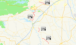
Highway 128 (AR 128, Ark. 128, and Hwy. 128) is a designation for four east–west state highways in the Southwest Arkansas. One route of 11.99 miles (19.30 km) begins at Highway 7 in Sparkman and runs east to Highway 9 at Holly Springs. A second route of 6.23 miles (10.03 km) begins at Highway 51 at Joan and runs east to Highway 7/Highway 8 at Gravel Junction. A third route begins at Highway 7 near DeGray Lake Resort State Park and runs east and north to US Highway 270 Business (US 270B) in Hot Springs. A fourth route begins at Highway 5 in Fountain Lake and runs east to US 70. All routes are maintained by the Arkansas State Highway and Transportation Department (AHTD).
History
Major intersections
| County | Location | mi[1] | km | Destinations | Notes | ||
|---|---|---|---|---|---|---|---|
| Dallas | Sparkman | 0.00 | 0.00 | Western terminus | |||
| Pine Grove | 5.53 | 8.90 | AR 207 northern terminus | ||||
| | Proposed intersection | ||||||
| Holly Springs | 11.99 | 19.30 | Eastern terminus | ||||
| Gap in route | |||||||
| Clark | Joan | 0.00 | 0.00 | Western terminus | |||
| Gravel Junction | 6.23 | 10.03 | Eastern terminus | ||||
| Gap in route | |||||||
| Hot Spring | | 0.00 | 0.00 | Western terminus | |||
| Caney | 3.96 | 6.37 | AR 283 northern terminus | ||||
| De Roche | 9.51– 0.00 | 15.30– 0.00 | |||||
| Garland | | 6.65– 0.00 | 10.70– 0.00 | ||||
| Hot Springs | 3.44 | 5.54 | Exit 7 | ||||
| 3.88 | 6.24 | Eastern terminus | |||||
1.000 mi = 1.609 km; 1.000 km = 0.621 mi
| |||||||
See also
-
 Arkansas portal
 -
 U.S. Roads portal
References
- 1 2 3 System Information and Research Division (2014). "Arkansas Road Log Database" (MDB). Arkansas State Highway and Transportation Department. Retrieved March 27, 2016.
- "Minutes of the Meeting" (PDF). Arkansas State Highway Commission. 1953–69. Retrieved November 20, 2016.
- "Minutes of the Meeting" (PDF). Arkansas State Highway Commission. 1970–79. Retrieved November 20, 2016.
- "Minutes of the Meeting" (PDF). Arkansas State Highway Commission. 1980–89. Retrieved November 20, 2016.
This article is issued from Wikipedia - version of the 11/28/2016. The text is available under the Creative Commons Attribution/Share Alike but additional terms may apply for the media files.