Social Hill, Arkansas
| Social Hill, Arkansas | |
|---|---|
| Unincorporated community | |
 Social Hill, Arkansas  Social Hill, Arkansas | |
| Coordinates: 34°19′55″N 92°54′48″W / 34.33194°N 92.91333°WCoordinates: 34°19′55″N 92°54′48″W / 34.33194°N 92.91333°W | |
| Country | United States |
| State | Arkansas |
| County | Hot Spring |
| Elevation | 344 ft (105 m) |
| Time zone | Central (CST) (UTC-6) |
| • Summer (DST) | CDT (UTC-5) |
| Area code(s) | 501 |
| GNIS feature ID | 78400[1] |
Social Hill is an unincorporated community in Hot Spring County, Arkansas, United States. Social Hill is located near Interstate 30 and Arkansas Highway 84 6.1 miles (9.8 km) west-southwest of Malvern.[2]
References
- ↑ "Social Hill". Geographic Names Information System. United States Geological Survey.
- ↑ Hot Spring County, Arkansas General Highway Map (PDF) (Map). Arkansas State Highway and Transportation Department. 2007. Retrieved February 15, 2013.
Municipalities and communities of Hot Spring County, Arkansas, United States | ||
|---|---|---|
| Cities | 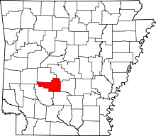 | |
| Towns | ||
| Unincorporated communities | ||
This article is issued from Wikipedia - version of the 7/29/2016. The text is available under the Creative Commons Attribution/Share Alike but additional terms may apply for the media files.