Bílý Kostel nad Nisou
| Bílý Kostel nad Nisou | |
|---|---|
| Municipality | |
_s_farou_02.jpg) | |
 Bílý Kostel nad Nisou | |
| Coordinates: 50°49′25″N 14°55′29″E / 50.82361°N 14.92472°ECoordinates: 50°49′25″N 14°55′29″E / 50.82361°N 14.92472°E | |
| Country |
|
| Region | Liberec |
| District | Liberec |
| Area | |
| • Total | 25.73 km2 (9.93 sq mi) |
| Population (2016) | |
| • Total | 943 |
| • Density | 37/km2 (95/sq mi) |
| Postal code | 463 31 |
| Website | http://www.bily-kostel.cz/ |
Bílý Kostel nad Nisou (German: Weißkirchen) is a village and municipality (obec) in Liberec District in the Liberec Region of the Czech Republic.
The municipality covers an area of 25.73 square kilometres (9.93 sq mi), and has a population of 943 (as of 2016).
Bílý Kostel nad Nisou lies approximately 11 kilometres (7 mi) west of Liberec and 90 km (56 mi) north of Prague.
Gallery
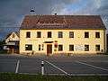 Municipal office
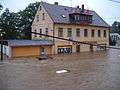 Floods in 2010
 Local part Pekařka
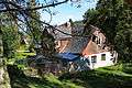 Local part Panenská Hůrka
Sources
- Municipal website (Czech)
- UIR.cz Územně identifikační registr ČR (Czech)
| Wikimedia Commons has media related to Bílý Kostel nad Nisou. |
This article is issued from Wikipedia - version of the 5/26/2016. The text is available under the Creative Commons Attribution/Share Alike but additional terms may apply for the media files.