Back Gate, Arkansas
| Back Gate, Arkansas | |
|---|---|
| Unincorporated community | |
 Back Gate Back Gate's location in Arkansas | |
| Coordinates: 33°55′14″N 91°20′12″W / 33.92056°N 91.33667°WCoordinates: 33°55′14″N 91°20′12″W / 33.92056°N 91.33667°W | |
| Country |
|
| State |
|
| County | Desha |
| Township | Silver Lake |
| Elevation | 49 m (161 ft) |
| Time zone | Central (CST) (UTC-6) |
| • Summer (DST) | CDT (UTC-5) |
| GNIS feature ID | 45995 |
| U.S. Geological Survey Geographic Names Information System: Back Gate, Arkansas | |
Back Gate, Arkansas is an unincorporated community in Desha County, Arkansas, United States.[1] The community is located at the corner of U.S. Route 165 and Arkansas Highway 1.[2]
Back Gate has been noted for its unusual place name.[3]
References
- ↑ "Feature Detail Report for: Back Gate, Arkansas." USGS. U.S. Geological Survey Geographic Names Information System: Back Gate, Arkansas Retrieved January 20, 2011.
- ↑ Arkansas Atlas and Gazetteer (Map) (Second ed.). DeLorme. § 59.
- ↑ Thompson, George E. (1 July 2009). You Live Where?: Interesting and Unusual Facts about where We Live. iUniverse. p. 7. ISBN 978-1-4401-3421-0.
Municipalities and communities of Desha County, Arkansas, United States | ||
|---|---|---|
| Cities | 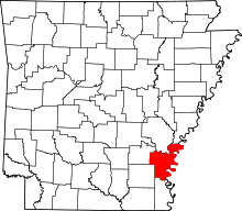 | |
| Towns | ||
| Unincorporated communities | ||
| Ghost town | ||
| Footnotes | ‡This populated place also has portions in an adjacent county or counties | |
This article is issued from Wikipedia - version of the 9/27/2016. The text is available under the Creative Commons Attribution/Share Alike but additional terms may apply for the media files.