Beehive, Montana
| Beehive, Montana | |
|---|---|
| Unincorporated community | |
 Beehive, Montana  Beehive, Montana | |
| Coordinates: 45°28′44″N 109°43′14″W / 45.47889°N 109.72056°WCoordinates: 45°28′44″N 109°43′14″W / 45.47889°N 109.72056°W | |
| Country | United States |
| State | Montana |
| County | Stillwater |
| Elevation | 4,629 ft (1,411 m) |
| Population (2010)[1] | |
| • Total | 32 |
| Time zone | Mountain (MST) (UTC-7) |
| • Summer (DST) | MDT (UTC-6) |
| ZIP code | 59001 |
| Area code(s) | 406 |
| GNIS feature ID | 777090[2] |
Beehive is an unincorporated community located in Stillwater County, Montana and shares a postal ZIP code with Absarokee (59001).
The elevation is 4,629 feet. Beehive appears on the Beehive U.S. Geological Survey Map.
History
Beehive was established as a town in a deep valley along the Stillwater River west of Absarokee. Beehive had a post office from 1910 to 1953. The community still thrives as a getaway destination with many seasonal mountain homes. Beautiful scenery along with great fishing can be found in and around Beehive.
References
- ↑ "American FactFinder". United States Census Bureau. Archived from the original on 2013-09-11. Retrieved 2011-05-14.
- ↑ "Beehive". Geographic Names Information System. United States Geological Survey.
Municipalities and communities of Stillwater County, Montana, United States | ||
|---|---|---|
| Town | 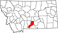 | |
| CDPs | ||
| Unincorporated communities | ||
| Ghost towns | ||
This article is issued from Wikipedia - version of the 10/29/2016. The text is available under the Creative Commons Attribution/Share Alike but additional terms may apply for the media files.