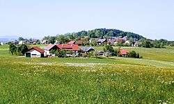
Berg im Attergau
| Berg im Attergau | ||
|---|---|---|
 | ||
| ||
 Berg im Attergau Location within Austria | ||
| Coordinates: 47°56′31″N 13°31′32″E / 47.94194°N 13.52556°ECoordinates: 47°56′31″N 13°31′32″E / 47.94194°N 13.52556°E | ||
| Country | Austria | |
| State | Upper Austria | |
| District | Vöcklabruck | |
| Government | ||
| • Mayor | Ernst Pachler (ÖVP) | |
| Area | ||
| • Total | 20 km2 (8 sq mi) | |
| Elevation | 654 m (2,146 ft) | |
| Population (1 January 2016)[1] | ||
| • Total | 1,028 | |
| • Density | 51/km2 (130/sq mi) | |
| Time zone | CET (UTC+1) | |
| • Summer (DST) | CEST (UTC+2) | |
| Postal code | 4880 | |
| Area code | 07667 | |
| Vehicle registration | VB | |
Berg im Attergau is a municipality in the district of Vöcklabruck in the Austrian state of Upper Austria.
Population
| Historical population | ||
|---|---|---|
| Year | Pop. | ±% |
| 1991 | 1,106 | — |
| 2001 | 987 | −10.8% |
| 2008 | 1,003 | +1.6% |
| 2016 | 1,028 | +2.5% |
References
| Wikimedia Commons has media related to Berg im Attergau. |
This article is issued from Wikipedia - version of the 3/17/2016. The text is available under the Creative Commons Attribution/Share Alike but additional terms may apply for the media files.