Cetechovice
| Cetechovice | |
|---|---|
| Municipality | |
|
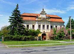
Cetechovice Castle | |
 Cetechovice | |
| Coordinates: 49°10′58″N 17°15′51″E / 49.18278°N 17.26417°ECoordinates: 49°10′58″N 17°15′51″E / 49.18278°N 17.26417°E | |
| Country |
|
| Region | Zlín |
| District | Kroměříž |
| Area | |
| • Total | 7.48 km2 (2.89 sq mi) |
| Elevation | 328 m (1,076 ft) |
| Population (2006) | |
| • Total | 178 |
| • Density | 24/km2 (62/sq mi) |
| Postal code | 767 02 |
| Website | http://www.korycansko-zdounecko.cz/cetechovice |
Cetechovice is a village and municipality (obec) in Kroměříž District in the Zlín Region of the Czech Republic.
The municipality covers an area of 7.48 square kilometres (2.89 sq mi), and has a population of 178 (as at 28 August 2006).
Cetechovice lies approximately 16 kilometres (10 mi) south-west of Kroměříž, 30 km (19 mi) west of Zlín, and 229 km (142 mi) south-east of Prague.
Gallery
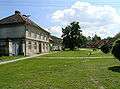 Common
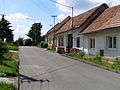 Side street
References
| Wikimedia Commons has media related to Cetechovice. |
This article is issued from Wikipedia - version of the 11/18/2016. The text is available under the Creative Commons Attribution/Share Alike but additional terms may apply for the media files.