Cozahome, Arkansas
| Cozahome, Arkansas | |
|---|---|
| Unincorporated community | |
 Cozahome, Arkansas  Cozahome, Arkansas | |
| Coordinates: 36°02′42″N 92°30′06″W / 36.04500°N 92.50167°WCoordinates: 36°02′42″N 92°30′06″W / 36.04500°N 92.50167°W | |
| Country | United States |
| State | Arkansas |
| County | Searcy |
| Elevation | 1,204 ft (367 m) |
| Time zone | Central (CST) (UTC-6) |
| • Summer (DST) | CDT (UTC-5) |
| ZIP codes | 72627 |
| Area code(s) | 870 |
| GNIS feature ID | 57596[1] |
Cozahome is an unincorporated community in Searcy County, Arkansas, United States. Cozahome is 12 miles (19 km) northeast of Marshall.
Cozahome has been noted for its unusual place name.[2]
Closest major highway
Although Arkansas Highway 14 is not in Cozahome, it is the closest major highway to the community.
References
- ↑ U.S. Geological Survey Geographic Names Information System: Cozahome, Arkansas
- ↑ Thompson, George E. (1 July 2009). You Live Where?: Interesting and Unusual Facts about where We Live. iUniverse. p. 7. ISBN 978-1-4401-3421-0.
Municipalities and communities of Searcy County, Arkansas, United States | ||
|---|---|---|
| Cities | 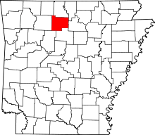 | |
| Towns | ||
| Townships | ||
| Unincorporated communities |
| |
| Footnotes | ‡This populated place also has portions in an adjacent county or counties | |
This article is issued from Wikipedia - version of the 9/27/2016. The text is available under the Creative Commons Attribution/Share Alike but additional terms may apply for the media files.