Cragford, Alabama
| Cragford, Alabama | |
|---|---|
| Unincorporated community | |
 Cragford, Alabama  Cragford, Alabama | |
| Coordinates: 33°15′03″N 85°40′21″W / 33.25083°N 85.67250°WCoordinates: 33°15′03″N 85°40′21″W / 33.25083°N 85.67250°W | |
| Country | United States |
| State | Alabama |
| County | Clay |
| Elevation | 860 ft (260 m) |
| Time zone | Central (CST) (UTC-6) |
| • Summer (DST) | CDT (UTC-5) |
| ZIP code | 36255 |
| Area code(s) | 256 & 938 |
| GNIS feature ID | 164043[1] |
Cragford is an unincorporated community in Clay County, Alabama, United States, located 6.3 miles (10.1 km) southeast of Lineville. Cragford has a post office with ZIP code 36255.[2][3]
References
- ↑ "Cragford". Geographic Names Information System. United States Geological Survey.
- ↑ United States Postal Service (2012). "USPS - Look Up a ZIP Code". Retrieved 2012-02-15.
- ↑ "Postmaster Finder - Post Offices by ZIP Code". United States Postal Service. Retrieved June 4, 2013.
Municipalities and communities of Clay County, Alabama, United States | ||
|---|---|---|
| City | 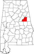 | |
| Town | ||
| CDPs | ||
| Unincorporated communities | ||
This article is issued from Wikipedia - version of the 7/31/2016. The text is available under the Creative Commons Attribution/Share Alike but additional terms may apply for the media files.