Csomád
| Csomád | ||
|---|---|---|
| ||
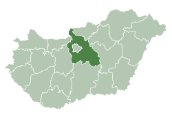
 Csomád Location of Csomád in Hungary | ||
| Coordinates: 47°39′14″N 19°14′12″E / 47.65388°N 19.23655°E | ||
| Country | Hungary | |
| Region | Central Hungary | |
| County | Pest | |
| Subregion | Veresegyházi | |
| Rank | Village | |
| KSH code | 33118[1] | |
| Area[2] | ||
| • Total | 12.39 km2 (4.78 sq mi) | |
| Population (1 January 2008)[3] | ||
| • Total | 1,313 | |
| • Density | 110/km2 (270/sq mi) | |
| Time zone | CET (UTC+1) | |
| • Summer (DST) | CEST (UTC+2) | |
| Postal code | 2161 | |
| Area code | +36 28 | |
| Website | www.csomad.hu | |
Csomád is a village in Pest county, Budapest metropolitan area, Hungary. It has a population of 1,193 (2007).
References
- ↑ Csomád at the Hungarian Central Statistical Office (Hungarian).
- ↑ Csomád at the Hungarian Central Statistical Office (Hungarian).
- ↑ Csomád at the Hungarian Central Statistical Office (Hungarian). 1 January 2008
Coordinates: 47°40′N 19°14′E / 47.667°N 19.233°E
This article is issued from Wikipedia - version of the 3/19/2013. The text is available under the Creative Commons Attribution/Share Alike but additional terms may apply for the media files.