Deerfield, New Jersey
For the township, see Deerfield Township, New Jersey.
| Deerfield, New Jersey | |
|---|---|
| Unincorporated community | |
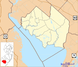 Deerfield  Deerfield  Deerfield Deerfield's location in Cumberland County (Inset: Cumberland County in New Jersey) | |
| Coordinates: 39°31′25″N 75°14′10″W / 39.52361°N 75.23611°WCoordinates: 39°31′25″N 75°14′10″W / 39.52361°N 75.23611°W | |
| Country |
|
| State |
|
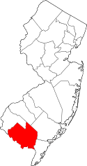
| County | Cumberland |
| Township | Upper Deerfield |
| Elevation | 36 m (118 ft) |
| Time zone | Eastern (EST) (UTC-5) |
| • Summer (DST) | EDT (UTC-4) |
| ZIP code | 08313 |
| Area code(s) | 856 |
| GNIS feature ID | 875864[1] |
Deerfield (also known as Deerfield Street) is an unincorporated community located within Upper Deerfield Township, Cumberland County, New Jersey, United States.[2] Deerfield is located on New Jersey Route 77 6.6 miles (10.6 km) north of Bridgeton.[3] Deerfield has a post office with ZIP code 08313; the post office uses the Deerfield Street name.[4][5]
References
- ↑ "Deerfield". Geographic Names Information System. United States Geological Survey.
- ↑ Locality Search, State of New Jersey. Accessed June 9, 2016.
- ↑ Cumberland County (PDF) (Map). New Jersey Department of Transportation. Retrieved July 27, 2013.
- ↑ United States Postal Service (2012). "USPS - Look Up a ZIP Code". Retrieved 2012-02-15.
- ↑ "Postmaster Finder - Post Offices by ZIP Code". United States Postal Service. Retrieved July 27, 2013.
This article is issued from Wikipedia - version of the 6/10/2016. The text is available under the Creative Commons Attribution/Share Alike but additional terms may apply for the media files.