La Vallee, Ontario
See also: La Vallee (disambiguation)
| La Vallee, Ontario | |
|---|---|
| Township (single-tier) | |
| Township of La Vallee | |
|
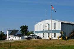
Municipal office in Devlin | |
 La Vallee, Ontario | |
| Coordinates: 48°37′N 93°39′W / 48.617°N 93.650°WCoordinates: 48°37′N 93°39′W / 48.617°N 93.650°W | |
| Country |
|
| Province |
|
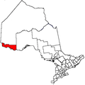
| District | Rainy River |
| Government | |
| • Reeve | Ken McKinnon |
| • Federal riding | Thunder Bay—Rainy River |
| • Prov. riding | Kenora—Rainy River |
| Area[1] | |
| • Land | 237.50 km2 (91.70 sq mi) |
| Population (2011)[1] | |
| • Total | 988 |
| • Density | 4.2/km2 (11/sq mi) |
| Time zone | CST (UTC-6) |
| • Summer (DST) | CDT (UTC-5) |
| Postal Code | P0W 1C0 |
| Area code(s) | 807 |
| Website | www.lavallee.ca |
La Vallee is a township in the Canadian province of Ontario, located within the Rainy River District. It stretches for 6 miles (9.7 km) along the north side of the Rainy River, with a depth of 15 miles (24 km), and consists of the geographic townships of Devlin, Burriss and Woodyatt. The township had a population of 988 in the Canada 2011 Census.
Demographics
| Canada census – La Vallee, Ontario community profile | |||
|---|---|---|---|
| 2011 | 2006 | 2001 | |
| Population: | 988 (-7.4% from 2006) | 1067 (-0.6% from 2001) | 1073 (-5.0% from 1996) |
| Land area: | 237.50 km2 (91.70 sq mi) | 237.26 km2 (91.61 sq mi) | 237.26 km2 (91.61 sq mi) |
| Population density: | 4.2/km2 (11/sq mi) | 4.5/km2 (12/sq mi) | 4.5/km2 (12/sq mi) |
| Median age: | 40.9 (M: 40.4, F: 41.4) | 39.4 (M: 39.7, F: 39.2) | 36.9 (M: 38.3, F: 35.4) |
| Total private dwellings: | 383 | 392 | 374 |
| Median household income: | $76,811 | $57,680 | |
| References: 2011[1] 2006[2] 2001[3] | |||
Population trend:[4]
- Population in 2011: 988
- Population in 2006: 1067
- Population in 2001: 1073
- Population in 1996: 1130
- Population in 1991: 1081
See also
References
- 1 2 3 "La Vallee census profile". 2011 Census of Population. Statistics Canada. Retrieved 2012-03-30.
- ↑ "2006 Community Profiles". Canada 2006 Census. Statistics Canada. March 30, 2011. Retrieved 2011-05-03.
- ↑ "2001 Community Profiles". Canada 2001 Census. Statistics Canada. February 17, 2012. Retrieved 2011-05-03.
- ↑ Statistics Canada: 1996, 2001, 2006 census
 |
Unorganized Rainy River | | ||
| Emo | |
Unorganized Rainy River Alberton | ||
| ||||
| | ||||
| Rainy River |
This article is issued from Wikipedia - version of the 8/5/2016. The text is available under the Creative Commons Attribution/Share Alike but additional terms may apply for the media files.